


Vous consultez notre ancien site web, accédez au nouveau site sur www.openstreetmap.fr
Agrégateur de flux
Meeting face-to-face at SOTM Denver
Activation in Somalia
End of an Era or at Least Internship
Schuyler Erle’s presentation at State Of The Map EU
Keren OSM (Bantaeng and Kupang, Indonesia)
Cartoparty à Mondevert
Samedi 26 novembre, nous étions trois membres de Gulliver à Mondevert pour une cartoparty OpenStreetMap. Après une demi-heure d'explications sur ce qu'est OpenStreetMap et comment on peut y contribuer, nous sommes parti sur le terrain, GPS et appareil photo en main, pour compléter la carte. Toutes les informations relevées n'ont pas encore été reportées dans OpenStreetMap mais la carte a déjà été complétée par des chemins piétonniers et quelques lieux d'intérêts. Un plan MapOSMatic est également disponible.
Nous avons même eu droit à un court article dans Ouest France ! (malheureusement avec beaucoup d'inexactitudes)
Poverty Mapping with an OpenStreetMap Base in Sumbawa
During HOT’s time working in Indonesia we’ve met with many different groups doing different types of mapping. One of the more common types is poverty mapping. This week we returned to Sumbawa for the third time to work with groups from Dompu and Bima.
The first time we were on Sumbawa in June was to teach the basics of OpenStreetMap as part of our pilot program with the Australia-Indonesia Facility for Disaster Reduction (AIFDR). Here we were working with Australian Community Development and Civil Society Strengthening Scheme (ACCESS) and their partners. Everyone was excited after this first two day workshop, but the need for more hands-on and practical knowledge was needed. Jeff Haack and myself returned in August each to work separately with a group on the goal of mapping an entire village. The four days of hands-on work got everyone very comfortable with mapping and near the end we discussed further possibilities. It was interesting to return again this week and see where the groups had taken them. Each group had taken their mapping even further but in different ways.
SOLUD is an ACCESS partner and a local Non-Governmental Organization (NGO) in Bima, they were primarily concerned about health data. Much of the data however could not be uploaded into OpenStreetMap. Since we had left the last time they had begun making their own presets in JOSM (xml files that configure forms for editing). In these presets were health indicator data for households. Once the data was added it was saved as an OSM file and then imported into QGIS,files were shared between individuals on USB sticks. Our goal in this training was to help create a more robust data collection strategy. One of the major points that came out of our previous training was the need for a way to link private data to public OpenStreetMap data, so we were prepared for that.
Training in Bima (Picture Thanks to Ramecindiha Dedy)
During our two day training we focused on two things. The first was using Quantum GIS to create maps and perform analysis of the data that was already collected. One component of this was taking a spreadsheet with OpenStreetMap ID’s and linking it to a shapefile downloaded from GeoFabrik’s download site.This allowed thematic mapping of individual buildings by indicators. For example in the spreadsheet was listed those families receiving “rice for the poor.” This cumbersome workflow allowed us to end up with the specific type of map we wanted at the end, but was labor intensive.
After going through the process and showing what was possible with the data we introduced the private datastore. This was to show how workflows could be improved if the linking process was made more easily. We created a form with the indicators they were interested in using. Next it will be key to create useful downloads of data of the private data they are collecting. Additionally after going through both of these lessons we also showed how to link pictures to information.
Our second stop in Dompu had much of the same questions and issues. They had come up with a completely different way to get around the problems though. First they mapped all the buildings and roads in OpenStreetMap, next they manually took screenshots of the data and imported it into Corel Draw. Once the map was in Corel Draw they traced over all the buildings and colored them based on their poverty level. With this method they were redo’ing a lot of work. This group had begun using QGIS some by manually typing all the IDs from OpenStreetMap into their Excel files. They had already done this for the entire village of Lanci Jaya (the one that Jeff worked with them to map in August). The main goal of this workshop was to use QGIS instead of Corel Draw to create a poverty indicator map. This way as the data is updated it could automatically update the map.
Now with a better workflow more analysis and decisions can be made. I can’t wait to see the results as we progress.
Training in Dompu (Picture Thanks to Emir Hartato)
Cartographier le monde avec des outils libres
Depuis maintenant 6 ans se tiennent chaque année à Polytech Nice les Journées Méditerranéennes des Logiciels Libres. Cet événement permet de regrouper pendant deux jours les différentes forces vives de l'Open Source du Sud de la France. Oubliez l'image d'un rassemblement de Geek (même si j'en ai croisé quelques-uns), l'accent est plutôt mis sur l'ouverture.
Meetings, Conferences and Coordination in Geneva
2 weeks ago Nicolas Chavent and I spent the week in Geneva. The initial impetus for the trip was the 3rd annual International Conference on Crisis Mapping (ICCM). Since there were many descending on Geneva for the event additional meetings were held. The two that we attended were the United Nations Office for Coordination of Humanitarian Affairs (OCHA) “Community of Interest” meeting and the United Nations Office for Outer Space Affairs (UNOOSA) “UN-Spider Experts Meeting: Crowdsource Mapping for Preparedness and Emergency Response.” Though meeting in the fine city of Geneva, Nicolas did simulate “fieldish” conditions by sleeping on a camping mat in a kitchen. I myself shared a room with some of the others attending the event.
ICCM has continued to grow and bring in more organizations since its start three years ago. About 400 people participated this year from organizations ranging from the UN to small individual hackers. Topics included everything from information security, to policy around satellite information, and early conflict detection and prevention.
I gave an Ignite presentation about HOT’s work in Indonesia. I will link to the video when it is available. For now my slides are on Slideshare.
The OCHA COI meeting occured the day before ICCM, this was the second of these such meetings. Back in June working groups were formed after a meeting held in New York City to discuss the volunteer response to the earthquake in Japan and the Libya CrisisMap. The goal is to figure out what is missing in coordination and to solve other problems. The current working groups are listed below, additional a separate group on Missing Persons has been formed and participated in the meeting.
- Cross Training
- Data Licensing
- Data Scramble
- Decision Makers Needs
- Humanitarian SBTF
- Impact Evaluation
- Preparedness & Prioritization
- Transition
- Volunteer Management
So far HOT has participated in the Data Licensing, Data Scramble and Preparedness & Prioritization groups. We can participate in more as people are interested in getting involved.
The second meeting hosted by UN-SPIDER was also the second gathering of people on this topic. The main initiative is to make access to satellite imagery easier for those who can help in a humanitarian response. This is particularly around crowd-sourcing. The initial meeting was mostly about discussing and presentations, the goal of this one was to work out details for a simulation. There is going to be a simulation on December 3rd surrounding a cyclone hitting Samoa. This was initiated by Dave Leng of HEAL Samoa who was present at both meetings. Dave should get the award for traveling the furthest and longest to make this meeting. Anyone interested in participated for HOT discussion so far is occurring on HOT’s mailing list.
The Amazing OSM Community, and the Tasking Server, Maps Swaziland
One month ago, I asked what to do with 10 million GPS points, and it turns out one awesome answer is map an entire country.
I wanted to experiment with the new HOT Tasking Server, so I set up a task using the Swaziland GPS tiles, but I didn’t bother to promote the effort at all. One month later, and the task is 100% complete, and about 25% verified. Amazing work by the community, and a quickly proven, easy to use, compelling tool.
Here’s Mbabane, the capital of Swaziland, before the editing.
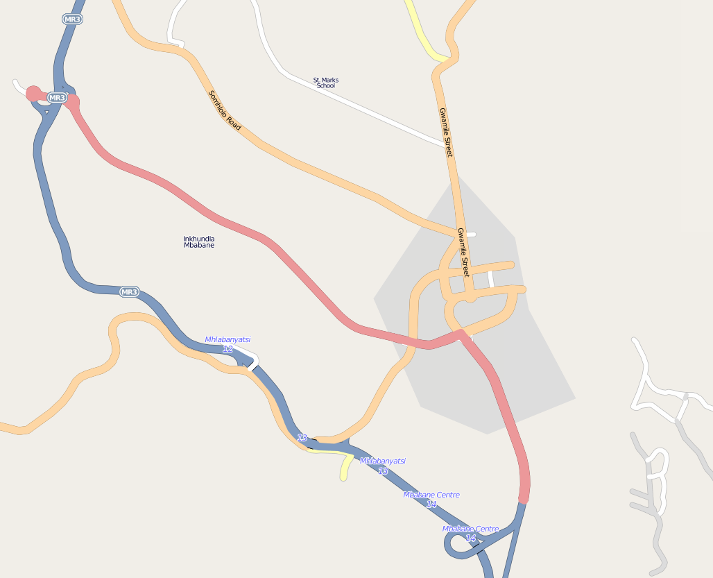
And here are the GPS traces of Mbabane, today.
And finally, the map today.
New roads have been filled in throughout the country. It would be interesting to calculate the growth in road features over this month.
There are still lots to do. There are gaps in the GPS coverage, and Bing might help. This was only roads, and unnamed, unclassified roads at that. It’s really now up to the small and growing community of mappers in Swaziland to bring the map alive.
I asked some of the incredible top contributors about why they took part in the mapping, and how the tasking server helped out.
The tasking tool is really nice to keep the motivation up and to keep track of what’s already done. You see the progress and the small chunks are mostly manageable.
It is good for my inner self. It is rewarding on both a greater scale (creating a needed map) as well as a smaller scale. Also, I find tracing a very relaxing activity that leaves my analytical programmer’s mind open for podcasting, talking or just recuperating from the day.
It was a chance to contribute to a very underdeveloped part of the map and make a real difference to what was available in that country. This is also a country that would take a long time to reach a critical mass of roads without outside work. Hopefully this will give a base for people when they look at a rendered map, which in turn might encourage other people in/near Swaziland to fill in the gaps.
I like mapping because you get to look at somewhere in more detail than you normally would. I now have a real feeling for the geography of Swaziland.
I’ve been interested in HOT for a while and participate when I can, but it’s not always clear how to contribute. The task manager made that easy. To the larger question of why do this at all: it’s like knitting a sweater for millions of people at once.
I think it’s important to get the tile size right. For the Swaziland tracing, it was perfect. I peeked at another task (tracing buildings in Indonesia) and a single tile was too overwhelming.
stethoscope’s insight on the right tile size was among many great points of feedback. We’re learning lots about how to improve the experience of the tasking server even more, that’s getting captured in issue requests, and Pierre continues to push development.
It was after Haiti that this idea began brewing, with identified need for “Mechanical turk style process for working through and importing individual features from large imports” and “Tools for ongoing coordination and identifying needs, addressing the problem of what to map now?”. And really, it goes back to the search for Jim Gray. At my talk at Microsoft last weekend, I was fortunate enough to meet some of the team who worked on the first mechanical turk process for collaborative imagery interpretation … the inspiration has results!
cross-posted from GroundTruth Initiative
Revue de presse de la semaine du 24 Octobre
Cette semaine, une grosse partie de notre attention a été accaparée par les différentes annonces de chez Google.
OpenLayer Client Zoom : une solution pour les services tuilés
Les résolutions fixes proposées par les services tuilés sont un obstacle à l'interopérabilité. Une solution se profile côté client dans OpenLayers.
Extrait traduit d'un article CampToCamp (voir le billet).
Jusqu'à aujourd'hui, OpenLayers ne permettait pas l'affichage d'une couche tuilée dans des résolutions non supportées par le service de tuilage de la couche. Si une carte était chargée à une résolution que le service de tuilage ne supportait pas, alors des tuiles non existantes étaient réclamées et des images cassées étaient affichées sur la carte.
A l'occasion dd'un contrat avec Swisstopo, Camptocamp a travaillé à faire évoluer cette situation pour rendre possible l'affichage de couches tuilées à des résolutions non supportées par le service de tuilage. La logique est simple: lorsque la carte est positionnée sur une résolution non supportée par le service de tuilage, OpenLayers réclame les tuiles de cette couche dans des résolutions moindres, et redimensionne la div de la couche en utilisant le facteur d'échelle resolution_moindre/resolution_carte.
Parfaire le patch a été une petite épreuve, mais il a été finalement fusionné avec la branche développement d'OpenLayers. Un exemple de cette fonctionnalité est disponible en ligne. Testez-le !
Merci à Swisstopo pour avoir financé ce travail. Et remerciements spéciaux à Andreas Hocevar pour son aide et support, et pour le patch “positionnement de tuile basé sur pourcentages" sur lequel ce travail est fondé.
7 Indonesian Students goes to Denver for SotM and FOSS4G!
We hope you guys still remember about our project in Indonesia. There was a mapping competition happen during the project and the winner was announced on the second week of August. There are five winners, they are:
1) Irwan Maryon (University of Andalas, Padang)
2) Dimas Raharjo (University of Indonesia, Jakarta)
3) Irwan Abdul Rohman (Institute of Technology, Bandung)
4) Bakhtiar Arif Mujianto (Gadjah Mada University, Yogyakarta)
5) Andriya Gunartono (Institute of Technology Sepuluh November, Surabaya)
And these people deserved to go to State of the Map (SotM) and Free Open Source Software for Geospatial (FOSS4G) in Denver on September. But, unfortunately four of them didn’t manage to attend SotM because there was a visa issue. Somehow the consular officer refused their visa application, but we are very glad because they made it for FOSS4G!
It’s been a while since SotM and FOSS4G happened. But we still have a lot of story to share. Anyway, we think that SotM this year was beyond success! Based on Steve Coast keynote, there were 250 attendees, 159 are from the United States, and the rest were coming from 34 different countries, and more than 50 talks. And most people in the conference are very friendly. We also met with other scholars such as Guensmork Alcin from Haiti, Parveen Arora from India, Maning Sambale from Philippines, and Humberto Yances from Colombia. We also met with many people from around the world; each of them has different interest about using OpenStreetMap. There are mappers, some of them are developer; they are using OpenStreetMap for their products, and we were surprised that some of them also came because they just want to have fun. Anyway, it seems that all of us had fun especially on the last day where Gregory Marler with Iván Sánchez singing on the stage. The auction session was fun too, thanks for Steve Coast who bought $20 mystery box contain OpenStreetMap’s clappers and gave all the clappers to attendees.
OpenStreetMap Clappers!
When we were in FOSS4G, the atmosphere of the conference was slightly different from SotM. First, there was not too much twitter fan in FOSS4G. Second, every end of session, there was a lot of people moving to other room and it was funny because there was confusion between people who walk either on the left or right side. And the last one is, there was a musical performance brought by GeoGlobalDomination (Kate Chapman as herself, Iván Sánchez as Dr. Northingham, and Schuyler Erle as our hero: Captain Geo!). We didn’t think that there will be a musical in a conference, who knows! They should perform in general session! Anyway, same with SotM, there was a lot of people coming to FOSS4G with different interest. Just like quote from the musical “everyone is a mapper in their own way”
People who involve with Community Mapping Pilot in Indonesia at FOSS4G. L-R (top): Vasanthi Hargyono, Dimas Rahardjo, Kristy Van Putten (Australian Government), Bakhtiar Arif Mujianto, and Irwan Abdul Rohman. L-R (bottom): Kate Chapman, Irwan Maryon, and Andriya Gunartono.
Revue de presse de la semaine du 29 Août
Et c'est reparti !
Cette semaine quelques démos Raster assez bluffantes sur OpenLayers, un parseur de Shapefile en Javascript, une nouvelle version de MapProxy, ou encore un possible futur service OSM, OpenMetaMap.
Bonne lecture !
Tablette de WMS
Non, geOrchestra n'a pas été porté sur mobile (mais ça vient). Cet écran présente la superposition d'un flux WMS (PLU, parcelles cadastrales) avec un fond bing maps, le tout sur une tablette Asus/Android. Ceci grâce à l'application Locus disponible sur l'android market en versions gratuite et pro. D'une stabilité remarquable et regorgeant de fonctions pratiques (openstreetmap offline, réalité augmentée, interface avec les logiciels de navigation...), Locus permet de belles démos d'interopérabilité.
Investir ou pas sur les API/services non ouvertes
Dans quelques jours, l'API Yahoo sera fermée. Yahoo recommande à ses utilisateurs de se tourner vers celle de Nokia. Et dans un ticket d'OpenLayers on trouve :
Finally, the GoogleNG layer violates the overall intent of the terms of service that to use the tiles, you've got to use the whole map interface. The whole point is that you can't use the tiles directly.. Traduction: Finalement, la couche google viole l'esprit des conditions d'utilisation pour l'utilisation des tuiles, vous devez utiliser l'interface google maps complète. Le fait est que vous ne pouvez utiliser les tuiles directement.
La consommation directe des tuiles google par OpenLayers, une voie pressentie pour le support gmaps dans geOrchestra sans embarquer toute l'API Google, n'est donc plus possible. Dans les conditions d'utilisation de google maps, on lit en effet :
(a) No Access to Maps API(s) except through the Service. You must not access or use the Maps API(s) or any Content through any technology or means other than those provided in the Service, or through other explicitly authorized means Google may designate. For example, you must not access map tiles or imagery through interfaces or channels (including undocumented Google interfaces) other than the Maps API(s).
Le ticket 1590 prévoit que geOrchestra utilise les fonds google ou autres car ce besoin a été plusieurs fois exprimé : google couvre la terre entière, donc des périmètres d'étude bien éloignés de la zone INSPIRE... Mais ces évolutions|abandons|subtilités de licence posent question.
Il apparaît risqué d'investir sur des API dépendantes d'une décision du fournisseur, cf Google may, at any time, terminate its legal agreement with you or cease providing all or any part of the Service immediately without any notice if:...(d) providing the Service could create a substantial economic burden as determined by Google in its reasonable good faith judgment. Une lecture critique des conditions d'utilisation s'avère dans tous les cas indispensable avant d'engager les développements.
En investissant principalement sur les normes OGC, on se met à l'abri de ces risques.
[OSM] MapCraft, pour partager le gâteau
GeoTribu POI - XAPI MapQuest, OpenLayers, OpenStreetMap
Pour ce tutoriel, nous allons essayer de faire une application de A à Z - enfin presque :
[OSM] Fight !
Rapide re-stats sur la belgique
Voilà un billet rapide avec les dernières stats (oui oui j'adore ça...)
Au 23/06/11 Nous avons :
91037.82 km de 'motorway', 'residential','unclassified','tertiary','secondary','primary','living_street','trunk'
soit 2062,85km en plus depuis le 13/05
soit encore ~51 Km de route en plus chaque jour
nous avons aussi:
108011.89 km de 'motorway', 'residential','unclassified','tertiary','secondary','primary','living_street','trunk','track'
soit 3618,87 km en plus depuis le 13/05
soit encore ~90 Km de route (+semi carossables) en plus chaque jour.