


Vous consultez notre ancien site web, accédez au nouveau site sur www.openstreetmap.fr
Agrégateur de flux
GeoServer 2.1.3 est dans les bacs
GeoServer 2.1.3 est disponible au téléchargement. Il s'agit essentiellement d'une version de maintenance corrigeant des bugs, mais de nouvelles fonctions et améliorations s'y sont glissées. Pour geOrchestra, voici les changements notables et ce qu'ils peuvent apporter :
- WMS cascadés : authentification BASIC (GEOS-4672) et timeout param
(GEOS-4817) améliorent
la stabilité des WMS cascadés. Ceci permet de relayer les services tiers en
ajoutant les mécanismes de sécurité de geOrchestra.
- améliorations du support INSPIRE : attribut vocabulary pour les mots-clefs
(4658)
- support des processus WPS asynchrones (4819) pour les recherches portant sur les calculs scientifiques
On rappelle aussi que GeoServer propose maintenant un réflecteur animator
pectaculaire qui génère un GIF animé composé de cartes fabriquées à des pas de
temps successifs (voir
exemples de geosolutions).
Schuyler Erle and John Crowley join the board
Schuyler Erle and John Crowley join the board
We’d like to welcome two new members to the board of the Humanitarian OpenStreetMap Team:
Schuyler Erle – Long time pioneer of open Source geo-hacking, co-founder of the OSGeo Foundation and co-author of “Mapping Hacks”. Of course he is also a long time OpenStreetMapper and was an early proponent of OpenStreetMap for disaster response. John Crowley – Instrumental in helping with the release of imagery for use in OpenStreetMap, requiring patience and strategy in interfacing between big government and more informal organizations. With his connections John will be able to help shape the HOT for funding and future collaborations.Schuyler Erle and John Crowley contributed massively to the process of enabling and encouraging OpenStreetMap use in disaster response after the Haiti earthquake. See them together (along with Jeffrey Johnson) in this inspiring Where 2.0 presentation in 2010 (14 min video) as they look back at how OSM helped in Haiti.
The new board were elected (as announced on the HOT mailing list) along with accepting nominations for new HOT members, on Wed 14th December. Thankyou to all those who took part!
Photo of Schuyler Erle is CC-BY-SA-2 Chris Fleming
Activation to Map Libyan Health Facilities
Activation to Map Libyan Health Facilities
The World Health Organization (WHO) has asked HOT and the Stand By Task Force (SBTF) to activate to map health facilities in in Libya.
This is not an emergency activation, but still very important. The basic point is to get a final Health Facility Registry GIS layer for Libya, with the location type, status and name of health centers across the country. This helps WHO as the starting point for return and increase of crucial health services in Libya; geographic information is crucial for the Libyan health system to manage its services for benefit of all citizens.
Volunteers are asked to collect all available information on the net that can be used to create the registry. This Activation will end on January 15. Much of the work will take place in a shared Google Doc to start, with import into OSM after completion. This makes it easier to coordite with SBTF volunteers.
STEPS:
1) Email myself (mikel_maron yahoo com) and request to join the activation. Include your Skype id, if you’d like to join the public Skype chat. I’ll respond with links to the spreadsheets we’re using.
2) Fill out a GForm with your information. You need to fill this form only the first time you start working, you do not need to do this every time.
3) Go to the GSpreadsheet and start looking for Health Facilities in Libya. You DO NOT need to fill in all the information if you do not find them: try to add as many info as you can find but do not get crazy if you cannot find one of the requested info. Other volunteers will look for it. The information already contained in the spreadsheet needs to be completed and checked.
Under the License/Origin column, you will see different data sets with different licenses for any individual point. Some are ok to use with OSM (VRAM_WHO, ICRC), and some are clearly not (gmapmaker). OSM, of course, wants data thats free and open license wise. So as HOT, we can also contribute by finding an open source for places already mapped in un-free sources.
Otherwise, the task should be clear? We can discuss on the HOT list here, but please do not share the spreadsheets publicly for now.
Cooperation between HOT and DigitalGlobe in Turkey
Cooperation between HOT and DigitalGlobe in Turkey
Soon after the earthquake near Van, Turkey in October OpenStreetMap volunteers began mapping. Without new satellite imagery available this task was not going to be very effective. Fortunately Suha Ulgen contacted put me in touch with Sean Lowery from DigitalGlobe. There was a lot of imagery available for the area effected by the earthquake, just OpenStreetMap did not have access to it. That is where DigitalGlobe’s FirstLook service came in.
In support of the Turkish Earthquake response, DigitalGlobe donated access to its FirstLook product soon after the event. The FirstLook service, was served online to OpenStreetMap editors through a WMS service. DigitalGlobe describes the service as “The FirstLook product leverages DigitalGlobe’s constellation of three very high resolution satellites to minimize any wait time for post event data. FirstLook has delivered coverage of over 70 events of high public interest worldwide to date in 2011.”Allow those volunteering for the response to see highly accurate and detailed both pre and post event satellite imagery. The Humanitarian OpenStreetMap Team created areas of interest utilizing the Tasking Manager to direct people to areas where imagery was available and digitizing concentration was needed.
This was not the first time that DigitalGlobe has donated access to the FirstLook service in response to an event. The first was after the tsunami in the Sendai area of Japan earlier this year. Without access to high resolution imagery OpenStreetMap would not be able to assist in response to these events. Thanks DigitalGlobe for providing it in response to the October earthquake in Turkey and thank you to Suha for putting us together for this response.
To see fully how much data was added checkout this visualization from ITOWorld, depicting edits over the past 90 days.GeoServer : traduction de la doc en français
A propos d'interface francisée, vous pouvez voir en direct l'état d'avancement de la traduction grâce à transifex.net. Exemple pour l'interface WMS :
PIGMA : nouvelle plateforme / geOrchestra
- l'interface cartographique est plus réactive, elle est utilisable sur des écrans tactiles
- l'architecture repose sur GeoServer 2.1 : support WMS 1.3, WPS, extension INSPIRE
- le visualiseur bénéficie d'un système de configuration JSON très soupe d'emploi
- l'extracteur sait utiliser un buffer sur emprise, supporte ecw et jpeg2000
- le processus de build a été entièrement revu de façon à pouvoir configurer l'ensemble des modules, les construire et les déployer en une seule opération
- l'usage des données est monitoré avec précision
- des contributions externes : un client catalogue simplifié, un outil qualité reposant sur CSW
OpenFixMap version 0.3.0, des nouveautées sous le sapin
Hello à tous, à peine 1 semaine après la publication de la 1ere version publique de OpenFixMap, l'équipe... moi ... a décidé de publier une nouvelle version et d'enfin la rendre disponible à travers le market.
Au menu des festivités :
- Le changement de certains boutons pour que ce soit plus homogène
- Amélioration de l'écran d'affichage des erreurs
- Amélioration des informations récupérées par les analyseurs
- Ajout d'un gestionnaire rapport de plantage (sur base volontaire)
- La possibilité de fermer des erreurs
- Et les premières traductions et contributions : Français et Estonien !
Pour rappel, vous pouvez trouver plus d'info sur http://openfixmap.bmaron.net, le code sur Github et les traductions sur Transifex.
Revue de presse de la semaine du 5 Décembre
OpenFixMap: les erreurs d'OSM sur android
Ayant reçu récemment un smartphone android (Merci bcp!), je me suis intéressé au développement java/android ... Ma première idée a naturellement pointé du côté de OpenstreetMap... Quelques how-to, copier/coller et lignes de code plus tard, voici la première version de mon premier programme que je vous propose...
Soyez donc indulgent
OpenFixMap :Sur osm, on passe beaucoup de temps à ajouter des nouvelles choses ou corriger certains tracés... Des utilisateurs ou des logiciels rapportent des problèmes à la communauté qui, bien trop souvent ne les regarde pas... par faute de méconnaissance des outils, ou de problème de centralisation.
OpenFixMap se propose donc d'être votre assistant correction pour OSM.
Installez OFM sur votre smartphone android et emportez-le dans vos "mapping trip".
Téléchargez la liste des problèmes et prenez vos notes en conséquence.
OpenFixMap vas chercher pour vous les erreurs sur :
- MapDust
- KeepRight
- OpenStreetBugs
Vous aurez l'occasion également de rapporter vos propres bugs sur 2 des 3 plateformes supportés (d'autres devraient suivre ...)
Installation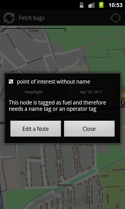
Pour installer OpenFixMap, il n'est pas encore possible de télécharger le logiciel sur l'android market, mais il suffit de vous rendre Ici pour la version v.0.2
ou d'utiliser le Qrcode suivant :
Le CodeBien sûr OpenFixMap est libre (GPLv3) et disponible sur Github. N'hésitez pas à commenter / patcher / forker / suggérer ... je suis là pour apprendre :D
ScreenshotsJ'ai bien sur mis une petite page en ligne pour l'occasion avec 2-3 captures d'écran (contenu en mauvais anglais...).
OpenStreetMap and Quantum GIS Training in Bali
OpenStreetMap and Quantum GIS Training in Bali
On 5th – 6th December 2011, HOT came to Bali for another training. Here we were working with Australian Community Development and Civil Society Strengthening Scheme (ACCESS) and their partners. The training was held in Puri Dalem Hotel, Sanur. This time we trained 17 people from 4 different areas. They are from Bali, Lombok, Sumba, and Selayar Island. These people are facilitator and they wanted to map their areas based on their needs. So we taught them basic OpenStreetMap things such as how to collect data using GPS and Walking Papers, then how to edit data with JOSM, and upload it to OpenStreetMap. We also taught them step-by-step what they can do with the data that they already collected with GIS software Quantum GIS (QGIS).
All training materials are collected from learnOSM.org with additional things that still are to be added on QGIS tutorial such as how to join spreadsheet file with the shapefile and using eVis plugin for adding pictures into attribute.
Based on our experience for training people around Indonesia, we expect that there will be some unexpected problem that would occur during the training. This time, we were struggling with windows virus when we tried to distribute all software and copies of training materials. We would recommend ourselves for next training to make another media for transferring all materials besides using USB sticks, either a CD or DVD.
Anyway, the training went pretty well, even we though our time was short because there were a lot of materials that we had to go over. Our QGIS tutorial experience was teaching in Sumba, in each district (Bima and Dompu) spending 2 days with 4-5 participants. But this time, we did one and a half day for OpenStreetMap basics and 4 hours for QGIS. We were glad that they feel these OpenStreetMap and QGIS are very useful and applicable for mapping their area based on their needs and interests.
People from Lombok are more interested to map social and economic map. The only problem that they have is accessibility to some villages because the roads are still bad and they do not have good satellite imagery in several areas. People from Sumba and Bali more or less will do the same thing with different number of villages that they would like to map. But, people from Sumba wanting us to comeback for attending their follow-up result in next year. They want to apply OpenStreetMap with QGIS for mapping then they will present the map result to their local governor.
There is one area that has problem, that area is Selayar Island, which has more than 10,000 km2 sizes. It does not have any point, line, and polygon on this island. Both Bing and Google do not have good satellite imagery. So, they are willing to propose a budget to their local governor to buy satellite imagery. We are really curious what would happen to this island after we gave them training. We hope that our efforts would keep their spirit to map the whole island.
Moreover, there is still a lot of work to support their mapping activities; we will keep in touch with them for technical issues and adding more guidelines in learnOSM.org.
Bilan des backports pour Openstreetmap
L'avantage indéniable de Debian sur d'autres distributions est à mes yeux sa stabilité exemplaire, cela entraine malheureusement d'avoir régulièrement des versions un peu obsolète des logiciels empaquetés. Il est possible de contourner cela en créant des backports de la version de développement de Debian (Wheezy) vers la version stable (Squeeze). J'ai réalisé les backports des principaux outils utilisés dans l'univers OpenStreetMap, ceux-ci sont diponibles sur mon dépôt privé (voir ce billet pour la mise en place du dépôt sur votre machine.
A ce jour les outils ci-dessous sont disponibles dans ces versions :
- dans-gdal-scripts 0.18
- gdal 1.7.3
- mapnik 2.0.0
- osm2pgsql 0.70.5
- openlayers 2.11
- gpsprune 13.1
- viking 1.2.1
Les paquets n'ont pas été poussés dans le dépôt des backports officiels car ils représentent une utilisation trop faible au vu de la communauté Debian, un paquet comme osm2pgql est utlilisé à ce jour par moins de 300 personnes d'après popcon quand les outils apache2 le sont par plus de 60000 (popcon apache2-utils).